

Case Study: The Derna Double Dam Breach (Derna, Libya, 2023)
By Michael Bennett, P.E., S.M.ASCE (Virginia Tech: Blacksburg, VA)
Author’s Note: This piece is dedicated to the memory of the victims of the failures of the Abu Mansour and Al-Bilad Dams on September 11th, 2023.
Introduction and Construction
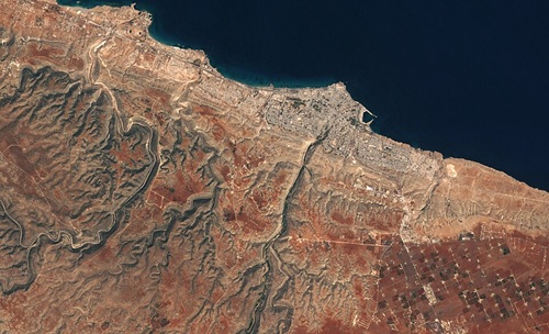
Derna, Libya is defined by its location on the Mediterranean Sea. In a largely arid nation, it stands out for its robust fishing industry, renowned seafood scene, thriving forests, and unusually moist climate. The city, population 100,000 as of 2023, lies atop an alluvial fan at the mouth of the Wadi Derna, wadi being Arabic for a riverbed. The waterway is typically dry, like most wadis, but this changes abruptly during the region’s infrequent yet torrential precipitation events. Thus, Derna has always been prone to flash flooding. Particularly severe floods struck the city in 1941 (sweeping away Nazi tanks), 1956, 1959, and 1968, highlighting the need for effective flood control. After Col. Muammar Qaddafi came to power in Libya in 1969, his government hired a Yugoslavian design and contracting firm to engineer and construct dams in the Wadi Derna valley. From 1973 to 1977, the firm built two earthen dams with compacted clay cores and rockfill faces. The Al-Bilad Dam, about 165 feet above sea level and just within Derna’s city limits, stood 80 feet high and had a storage capacity of 1,200 acre-feet. The Abu Mansour Dam, situated about 550 feet above sea level and 8.5 miles upriver (south) of the Al-Bilad Dam, stood 140 feet tall and had a storage capacity of 18,200 acre-feet. Collectively, the dams stored runoff and inflow from an area of about 215 square miles, most of which lay upstream of the Abu Mansour Dam (Mauney 2023, Nemnem et al. 2025, Schaer 2023, Yee 2024).
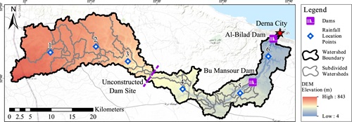
Source: Nemnem et al. (2025).
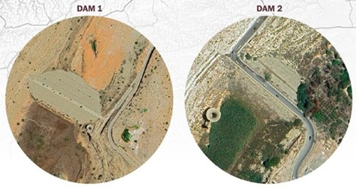
Source: Mellen et al. (2023).
Early Problems at the Dams and Political Turmoil
Decades of weathering and flash floods compromised the integrity of the Al-Bilad and Abu Mansour Dams. Reports of damage to the structures first emerged after severe floods in 1986. By the late 1990s, problems at the Wadi Derna dams grew so severe that the Qaddafi government became alarmed. When cracks were observed in the structures’ bases in 1998, the government hired Italian civil engineers to assess the dams and recommend repairs. The engineers confirmed the damage at the dams and provided guidance on how to properly rehabilitate them. The Italian study also recommended constructing a third dam in the Wadi Derna valley upstream of both extant structures to help them handle more severe floods than those the Yugoslavian designers had considered. The Qaddafi government hired a contractor in 2007 to carry out the recommendations of the Italian engineers, and work began in late 2010. However, when the Arab Spring convulsed Libya in 2011, Col. Qaddafi was overthrown and killed, and a brutal civil war engulfed the nation for almost a decade. Libya’s political situation stabilized in the late 2010s, but the repairs and third dam recommended in the Italian study never materialized (Boxerman and Glanz 2023, Mauney 2023, Schaer 2023).
Worsening Crisis at the Dams
By the early 2020s, the Al-Bilad and Abu Mansour Dams were increasingly at risk of failure. They had not been maintained for decades – 20 years by some local accounts, 40 by others – and vegetation was growing on the Abu Mansour Dam, a sign of internal leaks. Both dams had also been damaged during Libya’s civil war. Furthermore, as Derna’s population had swelled, their hazard classifications had changed. The structures had rendered the city’s frequent floods a distant memory, giving new residents a false sense of security, and new development often extended into the historical flood plain. Making matters worse, the population boom drained aquifers in the Wadi Derna region, which almost certainly impacted the dams. Satellite images from 2016 to 2023 showed 0.4 inches of groundwater-induced subsidence at the Al-Bilad Dam and 0.6 inches at the Abu Mansour Dam during that time. Finally, climate change was steadily altering the Derna region’s ordinarily temperate weather patterns, curtailing the growth of vegetation in the Wadi Derna valley and increasing the runoff the dams had to handle. Experts and locals, including a prominent Libyan civil engineer, warned for years of the impending danger from the dams’ lingering problems, but these concerns went unheeded (Boxerman and Glanz 2023, Mauney 2023, Mellen et al. 2023, Petley 2023, Schaer 2023, Shirzaei et al. 2025).
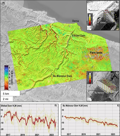
Source: Shirzaei et al. (2025).
Storm Daniel
In early September 2023, Storm Daniel, a Mediterranean cyclone (commonly called a “medicane”), barreled south from Greece toward Derna. Its barometric pressures were below those of most medicanes, and it arrived much earlier. Storm Daniel was further intensified by the unusually warm summer, which had heated the waters of the Mediterranean Sea. The medicane was also strengthened by anthropogenic climate change, which one study concluded had made it up to 50 times likelier and 50% worse. Before Storm Daniel neared Derna on Sunday, September 10th, the weather there had been rather dry; as of 6:30 PM, the reservoir behind the Abu Mansour Dam was empty. When the medicane rolled in later that evening, though, it dumped roughly 14 inches of rain over the Wadi Derna watershed. This rainfall corresponded to a storm of less than 0.1% annual probability, which is within the typical range of what a high hazard dam is designed to withstand. However, the ensuing runoff was seven times greater than the discharge capacities of the Al-Bilad and Abu Mansour Dams, an indicator that their spillways were woefully undersized (Armon et al. 2025, Boxerman and Glanz 2023, Mellen et al. 2023, Nemnem et al. 2025, Normand and Heggy 2024, Webber 2023).
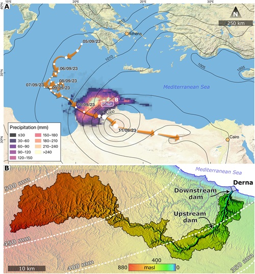
Source: Armon et al. (2025).
Edging Toward Failure
The dams’ problems worsened as September 10th slipped into the 11th. The Al-Bilad and Abu Mansour Dams would never have had high safety factors for slope stability during a medicane as intense as Storm Daniel. Post-flood geotechnical modeling found that the Abu Mansour Dam as built would have had an FS of 1.11 in the face of such a storm. Sadly, decades of insufficient maintenance had lowered these FS values even further, as cracks formed in the structures that led to high rates of seepage and piping and most likely accelerated their failure. Studies suggested that such cracks lowered the FS of Abu Mansour Dam from 1.11 to 1.07 – not a dramatic decrease, but enough to nudge the structure closer to failure (Nemnem et al. 2025).
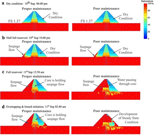
Source: Nemnem et al. (2025).
The Dams Breach
Eventually, the dams overtopped by several feet and failed. Eyewitness accounts indicate that the Al-Bilad Dam breached first, undergoing about 10 feet of overtopping before failing in the early hours of September 11th. The resulting flood wave inundated the lower floors of buildings throughout Derna and forced residents to high ground. Just a few hours later, at around 2:40 AM, the Abu Mansour Dam also breached after experiencing about 6.5 feet of overtopping. The torrent of water released in this second, much larger failure created an even higher flood wave through Derna. In total, the breaches let loose about 24,300 acre-feet of water. Thousands of Derna residents who had believed themselves to be on safe, high enough ground discovered to their horror that they were not (Nemnem et al. 2025, Shirzaei et al. 2025, Yee 2024).
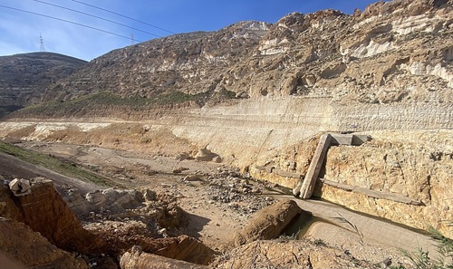
Source: Wikimedia Commons (2026).
Storm Daniel’s intense rains would certainly have hit the Wadi Derna valley hard even had the Al-Bilad and Abu Mansour Dams held, but their failures worsened the catastrophe by an order of magnitude. Researchers estimated via hydraulic modeling that the dam breaches deepened flooding across most of Derna by 6 to 20 feet compared to a no-dam scenario. Robust operations and maintenance procedures might not have saved the dams during Storm Daniel but could still have provided more time for evacuations. However, this added time might not have helped, since the region’s flood alert systems were functioning poorly. Derna residents reported that they not only received too little warning to evacuate before the breaches but that these notices were often wildly inaccurate – for instance, not advising people in the most flood-prone areas to seek higher ground. Thus, the dam failures turned an already bad disaster into a truly horrific one (Armon et al. 2025, Mauney 2023, Mellen et al. 2023, Nemnem et al. 2025).
Images 7 and 8:
Source: Wikimedia Commons (2026).
Source: Wikimedia Commons (2026).
Aftermath
The precise tally of victims from the Al-Bilad and Abu Mansour Dam breaches remains unknown. 4,000 people are confirmed to have perished, but the death toll is likely closer to 12,000. The disaster left 9 million tons of debris strewn across Derna, and the government’s ongoing cleanup and reconstruction of the city is currently projected to cost $2.1B. The double breach reminds dam and geotechnical engineers of their solemn obligations to properly assess risks from storms at dams and to design appropriately for these hazards (Boxerman and Glanz 2023, Normand and Heggy 2024, Yee 2023, Yee 2024).
Image 9: Aftermath of the dam breaches in Derna, September 2023. Source: Magdy (2023).
Acknowledgments
William Johnstone, Ph.D., P.Eng. (Spatial Vision Group: North Vancouver, BC), and Paul Risher, P.E. (US Army Corps of Engineers: Sacramento, CA), reviewed the entry’s technical content and directed the author to several valuable resources on the disaster. Sebastian Lobo-Guerrero, Ph.D., P.E., BC.GE (A.G.E.S., Inc.: Canonsburg, PA), the author’s former colleague, provided additional review. Gregory Richards, P.E. (GFT: Bountiful, UT), the author’s former colleague, provided the opportunity to write this entry as a case history for the Association of State Dam Safety Officials on their Dam Failures site at https://damfailures.org/case-study/abu-mansour-al-bilad-dams-libya-2023.
References
Armon, M., Y. Shmilovitz, and E. Dente. 2025. “Anatomy of a foreseeable disaster: Lessons from the 2023 dam-breaching flood in Derna, Libya.” Sci. Advances, 11 (13). https://www.science.org/doi/10.1126/sciadv.adu2865
Boxerman, A., and J. Glanz. 2023. “Dire warnings about Libya dam went unheeded.” New York Times, Sept. 16. https://www.nytimes.com/2023/09/16/world/middleeast/libya-dams-warnings.html
Magdy, S. 2023. “Libya was mired in chaos and corruption. For years, warnings the Derna dams may burst went unheeded.” Associated Press, Sept. 18. Accessed Apr. 25, 2026. https://apnews.com/article/libya-derna-dams-collapse-floods-corruption-neglect-chaos-45f76d2ac76be634865539a27b518ada
Mauney, L. 2023. “Derna, Libya Dam Failures: September 11, 2023.” ASDSO Dam Safety 2023, Palm Springs, CA. PowerPoint.
Mellen, R., L. Karklis, S. Granados, J. Ledur, and D. Stillman. 2023. “Mapping why Libya’s floods were so deadly.” Washington Post, Sept. 12. https://www.washingtonpost.com/world/2023/09/12/deadly-libya-flooding-cause/
Nemnem, A.M., A.H. Tanim, A. Nahian, S. Khan, E. Goharian, and J. Imran. 2025. “How extreme rainfall and failing dams unleashed the Derna disaster.” Nat. Commun., 16, 4191. https://www.nature.com/articles/s41467-025-59261-9
Normand, J.C.L., and E. Heggy. 2024. “Assessing flash flood erosion in Libya following storm Daniel in Libya.” Nat. Commun., 15, 6493. https://www.nature.com/articles/s41467-024-49699-8
Petley, D. 2023. “Further information about the Wadi Derna dams.” Eos, Sept. 14. https://eos.org/thelandslideblog/further-information-about-the-wadi-derna-dams
Schaer, C. 2023. “Derna: The Libyan city known for rebellion – and neglect.” Deutsche Welle, Sept. 15. https://www.dw.com/en/derna-the-libyan-city-known-for-rebellion-and-neglect/a-66822261
Shirzaei, M., F. Vahedifard, N. Sadhasivam, L. Ohenhen, O. Dasho, A. Tiwari, S. Werth, M. Azhar, Y. Zhao, R.J. Nicholls, and A. AghaKouchak. 2025. “Aging dams, political instability, poor human decisions and climate change: recipe for human disaster.” NPJ Natural Disasters, 2, 5. https://www.nature.com/articles/s44304-024-00056-1
Webber, T. 2023. “Climate change made storm that devastated Libya far more likely and intense, scientists say.” Associated Press, Sept. 19. https://apnews.com/article/climate-change-libya-flood-study-3eda9e77840d8bbd7058e494cc0a2231
Wikimedia Commons. 2026. “Search media: Images – Derna dam.” Wikimedia Commons. Accessed Apr. 25, 2026. https://commons.wikimedia.org/w/index.php?search=derna+dam&title=Special%3AMediaSearch&type=image
Yee, V. 2023. “Years of graft doomed 2 dams in Libya, leaving thousands in muddy graves.” New York Times, Sept. 27. https://www.nytimes.com/2023/09/27/world/middleeast/libya-flooding-derna-corruption.html
Yee, V. 2024. “A year after a deadly flood, a Libyan city is rebuilding but not whole.” New York Times, Sept. 14. https://www.nytimes.com/2024/09/14/world/middleeast/libya-floods-derna.html