
Case Study: The Frank Slide (Frank, AB, 1903)
By Michael Bennett, P.E., M.ASCE (Virginia Tech: Blacksburg, VA)
Author’s Note: This piece is dedicated to the memory of the victims of the Frank Slide of April 29th, 1903.
Introduction
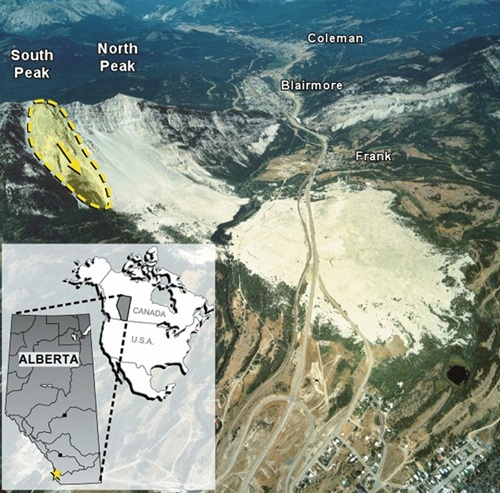
Only two factors kept the Frank Slide from being a site to behold as it roared down Turtle Mountain’s eastern flank in southwest Alberta on April 29th, 1903. One was timing. The disaster played out at 4:10 AM, when even the Canadian frontier’s hardy settlers were mostly still asleep. The other was tragedy. Most eyewitnesses in the best position to see or hear the monumental rockfall wound up entombed beneath it. Scholars and geo-professionals have spent the century and a quarter since the gargantuan slide studying its mechanics and the likelihood of further slides on Turtle Mountain’s slopes (Anderson 1986).
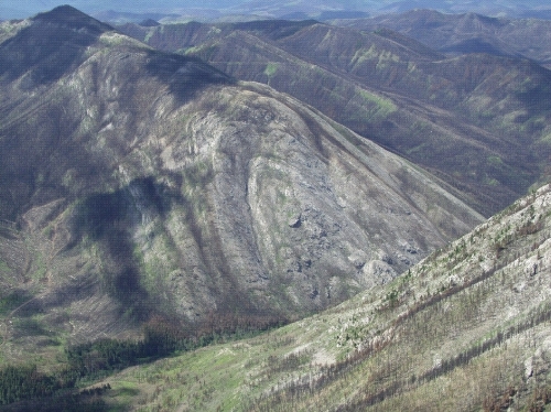
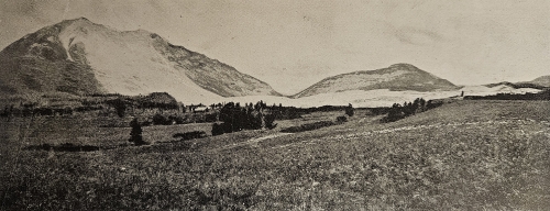
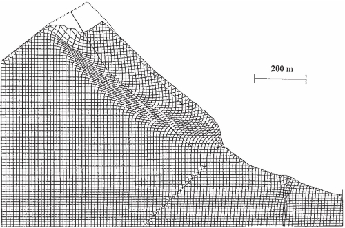
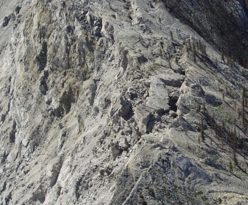
Source: Froese et al. (2009).
First Nations Lore and Geologic Background
The region’s First Nations residents, as Canada’s Indigenous peoples are known, had perceived the natural threat from Turtle Mountain long before 1903. Generations of the Blackfoot and Kootenay tribes had long refused to camp at the base of the peak, named because its profile resembled a sleeping turtle. They maintained in their folklore that the turtle would one day awaken and raise its head, bringing the mountain tumbling down. The First Nations peoples’ name for Turtle Mountain translated to “the mountain that moves,” which almost surely reflected the experience of previous slides. The mountain had been primed for such events since its formation during the Laramide Orogeny roughly 50 to 75 million years ago. The twisting, wrenching process of orographic uplift elevated the new peak about 3,000 feet (915 m) above the surrounding Crowsnest River valley, known as Crowsnest Pass. The orogeny and regional faulting eventually left the Livingstone Formation, a relatively strong stratum of Mississippian limestone roughly 1,150 feet (350 m) thick, lying above the Kootenay Formation, a series of considerably weaker strata of Cretaceous shale, sandstone, and coal about 655 feet (200 m) thick (Anderson 1986, Benko and Stead 1998, Langenberg et al. 2007, Leckie et al. 2021, McConnell and Brock 1904, Moreno et al. 2011, USGS 2025).
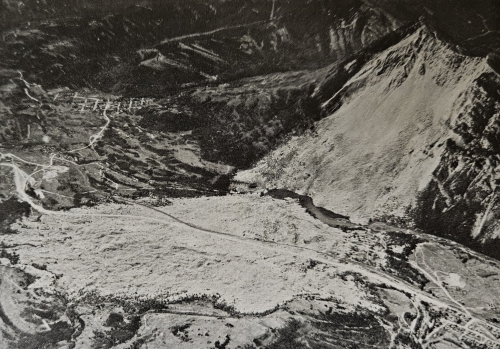
Source: McConnell and Brock (1904).
Source: McConnell and Brock (1904).
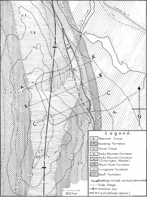
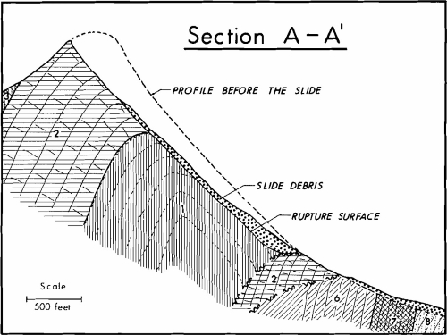
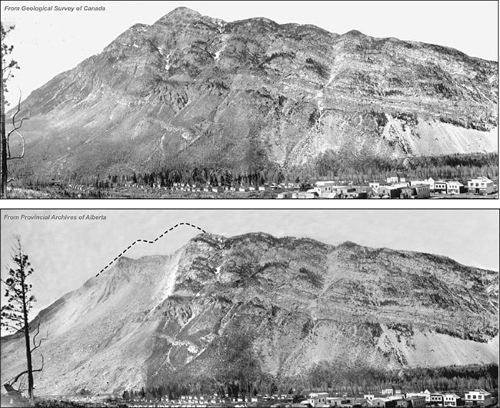
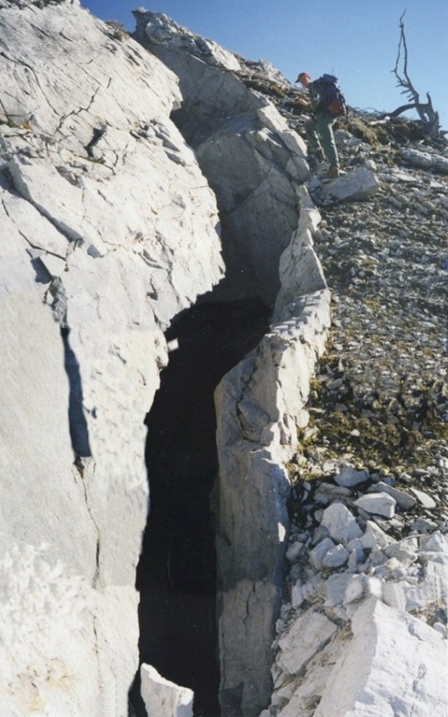
From the start, Turtle Mountain was tenuously stable at best. Its subsurface geology consists of crumpled rock strata riddled with faults, forming a fault-propagation fold. This structure manifests itself at the surface as the Turtle Mountain Anticline, the hinge of which defined the mountain’s crest as of early 1903. The Livingstone Formation limestone along the hinge has a lower, more widely scattered Geological Strength Index (GSI) than it does elsewhere on Turtle Mountain due to more closely spaced jointing and a lower unconfined compressive strength. West of the hinge, the formation dips 50° westward; east of the hinge, it dips 70° eastward. Post-slide studies would note two clearly defined joint sets through the hinge limestone, intersecting at a 97° angle. These fissures further complicated Turtle Mountain’s geologic situation by allowing water to seep in; freeze-thaw cycles then expanded them. The Turtle Mountain Fault, a thrust fault between the Livingstone limestone and the Kootenay sedimentary layers, only exacerbated the mountain’s stability woes. Multiple glaciations and the Kootenay Formation’s 82° westward dip left Turtle Mountain with a unique bilinear profile. In early 1903, the lower 800 feet (245 m) of the mountain’s 3,000-foot (915 m) prominence had a slope of about 30°, but above that, the mountainside had a slope of about 45° (Langenberg et al. 2007, Leckie 2021, McConnell and Brock 1904, Moreno et al. 2011).
Source: Read et al. (2005).
Source: Cruden and Krahn (1973).
Source: Cruden and Krahn (1973).
Pioneers and Coal
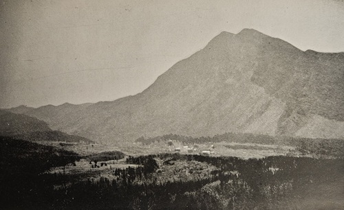
Clearly, the First Nations peoples’ fears about Turtle Mountain were geologically well-founded. Pre-1903 photos of the mountain show slight but definitive “pistol butt” trees along its eastern face and gaps in its vegetative cover, both indicative of current and historical rockfalls and slope movement. However, the First Nations peoples, and their prescience about Turtle Mountain, were driven out of Crowsnest Pass in the late 19th century as settlers reached the Canadian Rockies. The pioneers first noticed the area that would become Frank in the 1870s, when some discovered hot, sulfur-rich springs there. Developers eventually constructed a resort around these springs, touting their supposed medicinal benefits, but a stronger economic incentive was needed to attract more permanent settlement to Crowsnest Pass. That came shortly when the Canadian Pacific Railway laid tracks through the area. Further pioneers swiftly rode the rails to southwest Alberta, eager to find “gold in them hills” (Anderson 1986, Cruden and Martin 2007, McConnell and Brock 1904).
Instead, in 1900, a businessman exploring the region located an outcrop of one of the Kootenay Formation coal seams that ran beneath Turtle Mountain. Word of the vein soon reached Henry Luplin Frank, a Montana mineral magnate. He recognized that a coal mine promised steady, long-term profits and could anchor a sizable community. Accordingly, Frank formed the Canadian American Coal and Coke Company to work the seam, and mining began in the spring of 1901. By that fall, the company’s drifts and chambers extended nearly a quarter mile into the lucrative, 13- to 18-foot-thick (4 to 5.5 m) seam. Frank advertised the jobs his mine offered and made sure local aspiring businessmen heard that a town would spring up there. The coal boom and the Canadian Pacific tracks fueled a rapid, startling transformation. Over the next two years, the modest frontier settlement bloomed like wild grasses on the Canadian prairie. Unsurprisingly, it took the name of its founder – Frank (Alberta 2025, Anderson 1986).
Source: McConnell and Brock (1904).
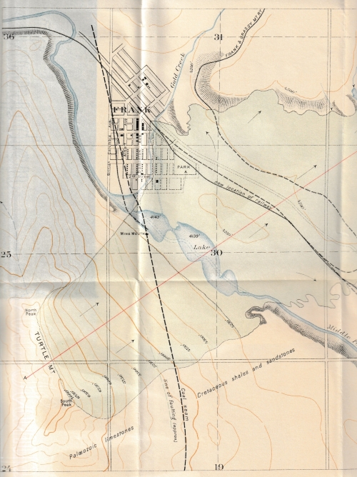
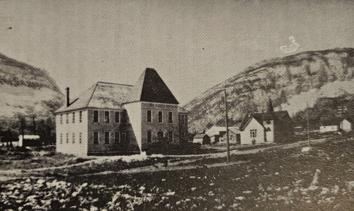
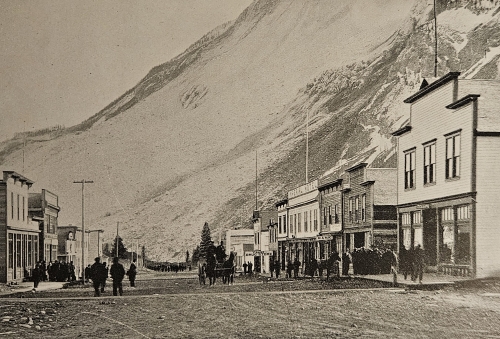
The Town of Frank
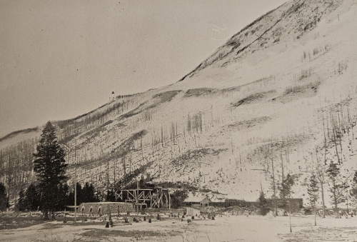
By 1903, roughly 600 people lived in Frank permanently alongside several hundred transient residents such as miners and ranchers. While the town was no metropolis, nor was it the “Wild West” outpost replete with shady characters that some historical accounts suggest. Visitors disembarking in Frank from a Canadian Pacific train could stay in one of three hotels. Those who liked what they saw and decided to put down roots – and there were many – could shop at two dry goods stores and two clothing shops. Two doctors, a dentist, and a well-stocked drug store were available for their medical needs, and an attorney and insurance agent could cover other serious concerns. The town bank’s deposits were locked in a safe guarded by its banker, who lived on the premises, and his four revolvers. Other businesses included a shoe store, a jeweler, wine and cigar shops, a fledgling newspaper, and a photographer, who would play a key role in capturing the slide’s aftermath for posterity (Anderson 1986).
Most denizens of Frank had built their own homes and lived with their families; some had as many as 7 children. A few mine employees and their families lived in company cottages, while others, most likely bachelors, lived in a boarding house. Tents on the Crowsnest River flats just outside town housed workers building a rail spur north from the Canadian Pacific’s main line. A theater gave the good townspeople the chance to unwind in their free hours; so, to the chagrin of Frank’s churches, did several saloons. Meanwhile, teachers in the two-story brick schoolhouse kept the town’s youths on the straight and narrow. Police records suggest that Frank was a rather orderly place, as the worst offenses recorded there were cattle and horse theft. The village had never needed more than two police officers to keep the peace, and one was usually sufficient (Anderson 1986).
Source: Anderson (1986).
Problems within the Mountain
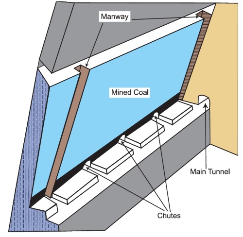
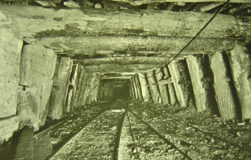
The most critical threat facing Frank in the early 1900s was far less visible than the occasional cattle rustler but far more menacing. Immediately south of town, Turtle Mountain was growing increasingly unstable. The alluvial fan accumulating at the mouth of Gold Creek, a local tributary of the Crowsnest River, had been diverting the river for years, causing the Crowsnest to slowly cut into the mountain’s eastern base. Moreover, 1899, 1901, and 1902 were all unusually moist years in Crowsnest Pass, causing more severe freeze-thaw cycles that worsened the degradation of the Livingstone Formation limestone. Deeper within Turtle Mountain, the Canadian American Coal and Coke Company was steadily accelerating its mining operations. Its coal output skyrocketed from 15,000 tons (13,600 t) in 1901 to 160,000 tons (145,000 t) in 1902, and miners extracted a further 101,000 tons (91,600 t) in the first four months of 1903. Quick expansion made the mine’s increasing output possible. By early 1903, its tunnels reached over a mile into Turtle Mountain. The mine’s working face consisted of three massive vertical chambers 250 to 400 feet (75 to 120 m) high and 60 to 150 feet (18 to 45 m) long within the 13- to 18-foot-thick (4 to 5.5 m) Kootenay Formation coal seam (Anderson 1986, McConnell and Brock 1904).
Source: Cruden and Martin (2007).
“When the timbers start talking, the miners start walking.”
The thick cover of talus and vegetation on Turtle Mountain’s eastern flank largely hid surface manifestations of its geological problems from view in Frank. No such camouflage blocked the view of miners toiling for H.L. Frank, though, and they reported ominous signs in the months leading up to the Frank slide. The newest section of the mine tunnel, extending 3,500 to 5,000 feet (1,065 to 1,525 m) into the mountain, exhibited frequent, troublesome squeezing. Coal in the mine’s mammoth chambers was increasingly “running itself,” or working loose from the vein without any mining effort. This reflected an increasing magnitude of stress relief within these chambers and, in turn, just how much stress was building up within Turtle Mountain’s strata. Perhaps most ominously, the stout 16-inch timbers installed to brace the mine’s workings were frequently twisted and splintered within a day of their installation. Miners noted that the issue was worst in the dead of night, which corresponded to the region’s lowest temperatures and induced the worst freeze-thaw cracking in the limestone. The failure of timber props in subsurface coal mines is a loud process, as peers of the Frank miners 2,000 miles away used to note in a darkly witty rhyme. The miners in northeast Pennsylvania’s anthracite region all knew that “When the timbers start talking, the miners start walking” (Anderson 1986, Cruden and Martin 2007, McConnell and Brock 1904).
Source: Underground Miners (2025).
Some Frank miners were indeed frightened enough by the talking timbers and other worrisome signs that they quit and walked off the job, but most kept working. The possibility of a massive geological failure at Turtle Mountain seemed remote, and the lure of profits was too sweet for the Canadian American Coal and Coke Company to resist. By then, H.L. Frank and his employees had fallen to some extent into the comfortable logical fallacy that since nothing had happened yet, nothing would. However, this calculus became increasingly shaky as April 1903 neared its end. Spring was finally reaching the Canadian Rockies, and ice within the joints of the Livingstone Formation limestone was beginning to melt, while ice along the joints’ external faces remained frozen. As a result, the water had nowhere to drain, and pore pressures in the rock were increasing. Several unusually warm days at Turtle Mountain late that April exacerbated this freeze-thaw problem. The issue grew even worse on the night of April 28-29 as temperatures fell below 0 °F (-18 °C). Miners recalled this unseasonable cold snap as being more frigid than any night that winter. The rapidly increasing pace of mining within Turtle Mountain likely compounded the freeze-thaw issues. One final piece of the failure puzzle was a minor thrust fault spur off the Turtle Mountain Fault, which represented a built-in sliding surface at the peak’s base. As April 28th, 1903 slipped into April 29th, Turtle Mountain was essentially standing up out of habit (Anderson 1986, Cruden and Krahn 1978, McConnell and Brock 1904).
Source: The Haunted Walk (2025).
The Frank Slide
The habit died hard at 4:10 the morning of April 29th when a wedge of limestone along Turtle Mountain underwent toppling, most likely due to freeze-thaw cycles. This failure cascaded into a rockfall avalanche, and the slide began. Most of Frank’s inhabitants were still sound asleep, but enough were awake to paint a terrifying picture of what happened. A hotelkeeper, already well into his workday, heard a tremendous roar that sounded like steam escaping under high pressure. He sprinted to his door just in time to glimpse gargantuan boulders bounding mere feet from his establishment. Over at the mine, a train engineer shunting freight cars along a siding heard the cacophony of falling rock and opened his throttle wide. The avalanche let loose a wave of air that nearly tipped over his engine, but he and his crew escaped by the skin of their teeth. The same air blast blew doors open in the Frank mine and knocked the men and horses inside off their feet. So loud was the slide that it was heard 110 miles (175 km) away on the outskirts of Calgary (Alberta 2025, Anderson 1986).
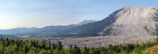
The avalanche of rock followed right behind the air wave. The slide let loose approximately 58 million cubic yards (44 million m3) of Livingstone Formation limestone weighing roughly 120 million tons (110 million t). For comparison, this constitutes enough material to lay 1 foot (0.3 m) of new pavement along the entire Trans-Canada Highway from St. John’s, Newfoundland, to Victoria, British Columbia. The falling rocks ranged in size from sand grains to 40 feet (12 m) in diameter, although most were between 3 and 20 feet (0.9 and 6 m). The rockslide thundered down the slopes of Turtle Mountain at up to 75 miles per hour (120 km/h) and hit the alluvium of the Crowsnest River with such force that the soil liquefied. This created a fluidized cushion that splattered the slide debris across the Crowsnest Pass (Alberta 2025, Anderson 1986, Cruden and Krahn 1973, McConnell and Brock 1904, Pletcher 2025, Read et al. 2005, Van Gassen and Cruden 1989).
Source: McConnell and Brock (1904).
Source: Cruden and Krahn (1978).
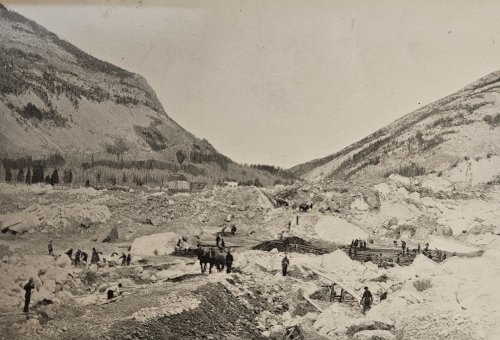
The Frank Slide lasted only about 90 seconds, but that was plenty of time for it to do its worst. When the slide finally halted, it had left a debris field ranging from 27 to 150 feet (8 to 45 m) thick, and on average about 45 feet (14 m) thick, over an area of 1.2 square miles (3 km2) in Crowsnest Pass. The fallen rock had dammed the Crowsnest River in several places, creating a chain of small lakes. The slide had also rerouted Gold Creek around the debris field’s southern edge. Canadian Pacific wound up needing 17 days and a force of 1,100 men to rebuild 1.25 miles (2 km) of track obliterated by the rock avalanche. The Canadian American Coal and Coke Company needed about a month to reopen its mine (Alberta 2025, Anderson 1986, Cruden and Krahn 1978, McConnell and Brock 1904, Read et al. 2005).
Source: Cruden and Martin (2007).
Source: McConnell and Brock (1904).
The popular impression that the Frank Slide wiped out its namesake town in its entirety is erroneous. The slide mainly impacted the southern end of town, and a large majority of Frank’s 600-odd citizens were physically and financially unaffected by it. The slide blocked the Frank mine entrance, but in a fortunate turn of events, the crew on duty that morning successfully excavated a vertical tunnel through the Kootenay Formation coal seam and escaped. Still, the disaster’s human consequences were grim, and at least one miner emerged from the rubble of Turtle Mountain only to find that his family had perished. The transient lifestyle of many who struck out for the Canadian Rockies in the early 1900s precludes a precise tally of victims of the Frank Slide, but the death toll was most likely around 90. The debris field was so massive that only 13 bodies were initially recovered, cruelly denying victims’ relatives even the opportunity for closure. In 1922, a highway construction crew in the Crowsnest Pass excavated the remnants of a home and 6 more bodies, which were appropriately interred. Today, approximately 70 victims of the Frank Slide remain buried in the debris field (Anderson 1986).
Source: McConnell and Brock (1904).
Initial Investigation and Early Failure Hypotheses
The Dominion of Canada – then part of the British Empire – quickly authorized a geological investigation of the Frank Slide. Government geologists R.G. McConnell and R.W. Brock swiftly headed to Crowsnest Pass, completed a meticulous observational study of the region, and interviewed eyewitnesses. Their report, presented to provincial authorities in June 1903, is a concise, lucid account of the disaster. Initial reports of the slide had speculated that a volcanic eruption, earthquake, or mine explosion might have been at play, but the geologists readily concluded that these theories were, “it is almost unnecessary to say, without foundation.” They reported that the fall of Turtle Mountain was a rockfall or block flow caused by toppling failures along joints within the Livingstone Formation limestone orthogonal to its bedding planes. McConnell and Brock also prudently recommended that serious consideration be given to relocating the town to avoid similar future disasters (McConnell and Brock 1904).
Source: McConnell and Brock (1904).
For many years, McConnell and Brock’s account of the Frank Slide’s mechanism was largely accepted. Prominent texts repeated their findings, as did Karl Terzaghi, the founder of modern geotechnical engineering, when he described the slide as a progressive failure brought about by coal mining. Meanwhile, the mine reopened and Frank returned to and even exceeded its pre-slide prosperity, reaching a population of 1,000 by 1910. Yet the question remained of whether Turtle Mountain would pose further problems. R.W. Brock returned to Crowsnest Pass to assess this danger in 1909 and 1910. He concluded based on crevasses he observed that the mountain’s North Peak still posed a risk of toppling. His stark assessment, along with a 1911 follow-up study, ultimately led to the Frank mine’s closure early in 1912; its namesake and founder, H.L. Frank, had passed away a few years earlier. Simultaneously, the entire town was relocated 2 miles northwest, out of the hypothesized rockfall zone. It became part of the neighboring village of Blairmore (Alberta 2025, Anderson 1986, Cruden and Krahn 1978, McConnell and Brock 1904, Sharpe 1938, Terzaghi 1950).
Source: McConnell and Brock (1904).
Source: Mei et al. (2008).
Further Research and Revised Failure Hypotheses
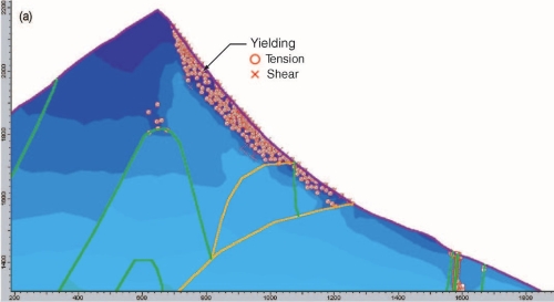
McConnell and Brock’s organized, scientifically rigorous report on the Frank Slide remains an invaluable read. It met the contemporary standard of care and incorporated the best information available to its authors. Yet its shortcomings slowly became apparent as the study of geology was further developed over subsequent decades. In 1904, an economic geology survey party searching for coal in southwest Alberta first mapped the Turtle Mountain Anticline. Further regional geological studies from the 1930s to the 1950s established that the Frank Slide had been a rockslide avalanche along the Livingstone Formation limestone in the anticline’s east limb. McConnell and Brock had mistakenly described the slide as a toppling failure across the formation’s bedding planes because it had obliterated the anticline’s axis and east limb at Turtle Mountain – a powerful example of survivor bias. The mid-century studies also found evidence of similarly sized paleo-landslides throughout the region, indicating that the disaster had not been a freak event. In the 1970s, geological engineering was first brought to bear in studying the Frank Slide by Professor David Cruden of the University of Alberta. He and his colleagues used direct shear tests to measure peak friction angle and cohesion values, ɸ′ and c′, of 28° and 32 psi (221 kPa) on the slide’s slip surface and of 32° and 25 psi (172 kPa) on the Livingstone limestone joints. When they assessed the stability of Turtle Mountain’s slopes using limit equilibrium analyses and these parameters, they obtained FS values below 1, showing just how precarious the mountain’s equilibrium had been (Cruden and Krahn 1973, Cruden and Krahn 1978).
More recent research, including further work by Professor Cruden, has used numerical modeling to reexamine the Frank Slide. In the late 1990s, scholars reassessed the failure with finite difference and discrete element method techniques, representing mining activity within their models by gradually removing material at Turtle Mountain’s base. FDM models generally agreed with the failure surface predicted by limit equilibrium analyses, but this agreement was weaker along the mountain’s crest due to these models’ inappropriate inherent assumption of material continuity in the highly jointed Livingstone Formation limestone. DEM models described the observed failure surface more accurately; in fact, these predicted the mountain’s failure even before the Frank mine had reached its final pre-slide extent. Researchers have also revisited the slide using FEM models, which cannot incorporate rock discontinuities but are thus far less computationally expense than DEM models. The FEM models also provided results that reasonably agreed with the observed rockslide avalanche. Debate persists as to just how much coal mining at Turtle Mountain’s base contributed to the slide. The FDM and DEM study cited it as a key factor, but the FEM study expressed more uncertainty about this, albeit without ruling it out (Benko and Stead 1998, Cruden and Martin 2007).
Source: Benko and Stead (1998).
Source: Cruden and Martin (2007).
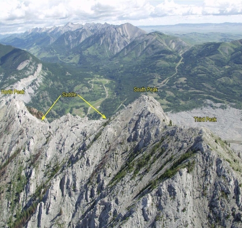
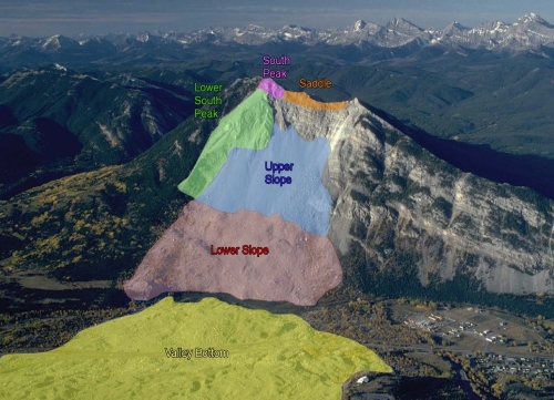
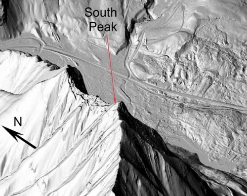
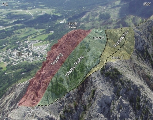
Threat of Another Slide and Early Monitoring Efforts
As early as June 1903, R.G. McConnell and R.W. Brock wrote after their field survey that the specter of another rockslide on Turtle Mountain “must always overhang the town” of Frank. The mountain’s North Peak was originally considered the most likely area for a future rockfall, as reflected in Frank’s relocation, but this belief evolved as awareness of the Turtle Mountain anticline became more widespread. During the 1930s, geologists first became concerned by the possibility of a slide as large as 6.6 million cubic yards (5 million m3) from the mountain’s South Peak. Accordingly, they installed the first manual gauges to assess the peak’s stability to better forecast such an event. Some of these gauges were still in operation in the 1980s, when Professor David Cruden and his colleagues orchestrated the first systematic efforts for monitoring Turtle Mountain and its South Peak. Their main instrument of choice was the moiré gauge, marking its first use in North America. The 2-D version of the device uses overlaid grids to monitor gradual displacement, while 3-D moiré gauges allow rotation and temperature to be measured as well. Cruden and his peers supplemented these gauges using seismometers, photogrammetry, and electronic surveys. Collectively, this instrumentation indicated that Turtle Mountain was moving enough to warrant continued monitoring but not enough to suggest an imminent major issue. Unfortunately, a funding shortfall led the monitoring to be discontinued in the mid-1990s, right around the time the Frank Slide’s final survivors passed away (Alberta 2025, Cruden and Krahn 1978, Froese et al. 2009, Froese and Moreno 2014, Kostak and Cruden 1990, McConnell and Brock 1904, Read et al. 2005).
Source: Mei et al. (2008).
Source: Kostak and Cruden (1990).
Source: Kostak and Cruden (1990).
Modern Monitoring of Turtle Mountain
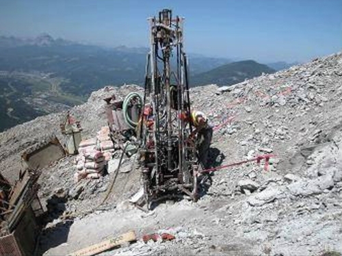
While funding to monitor Turtle Mountain stopped, the mountain kept moving. By June 2001, when 16,500 tons (15,000 t) of rock fell from its North Peak, active sliding and rockfalls had destroyed about half the 1930s rock stability gauges. Accordingly, Alberta’s provincial government marked the Frank Slide’s centennial in April 2003 by pledging CAD $1.1M ($2.7M in 2025 USD) to a state-of-the-art, multidisciplinary monitoring program for Turtle Mountain. Researchers first replaced seismic stations along the mountain, installed a weather station there, and constructed a monitoring control center at the Frank Slide Interpretive Centre, a visitors center opened just across the Crowsnest River in the mid-1980s. Next, they installed crack gauges, electronic/laser surveys, and GPS monitoring to assess deformation and breakage within fissures in Turtle Mountain’s South Peak. Finally, the team set up borehole instrumentation to keep tabs on displacement, temperature, pore pressures, and microseismicity within the mountain, along with systems to monitor springs at its toe (particularly from the former Frank mine). Incredibly, the researchers completed this set-up work within two years and supplemented their efforts by surveying Turtle Mountain with satellite-based InSAR from April 2004 to October 2006 (Froese et al. 2009, Mei et al. 2008, Read et al. 2005).
Source: Read et al. (2005).
Source: Mei et al. (2008).
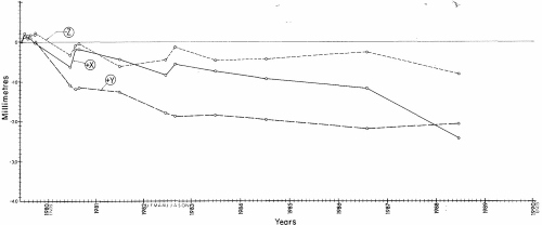
Initial results from the Turtle Mountain monitoring system demonstrated that it had been money well spent. The thick talus deposits on the mountain’s slopes made some measurements tough to interpret, but the data clearly showed that portions of the South Peak had moved as much as 3.5 inches (88 mm) between 1982 and 2005. The instrumentation also confirmed the presence of four major non-bedding joint sets within the South Peak. Given these findings, the Turtle Mountain monitoring system has been consistently funded over the past 20 years. It currently includes 22 crack gauges, 20 survey prisms, 12 GPS receivers, 10 tiltmeters, 5 extensometers, several web cameras, a weather station, and an outflow weir at the mountain’s base. Data from all these systems is wirelessly transmitted both to a nearby provincial office and to the control center at the Frank Slide Interpretive Centre, where it is reviewed daily and backed up weekly. Alarms are automatically tripped if readings exceed certain thresholds. A four-level alert system with prescribed protocols at each level ensures that emergencies are handled in as calm and orderly a manner as possible. Annual drills keep the warning system and those monitoring it prepared for worst-case scenarios, and the systems are checked every spring for snow damage (Froese and Moreno 2014, Froese et al. 2009, Mei et al. 2008, Read et al. 2005).
Source: Read et al. (2005).
Source: Mei et al. (2008).
So far, the news from researchers using the monitoring system to evaluate likely future rockslide activity at Turtle Mountain has been better than expected. To be sure, the mountain continues to move; “on an annual basis,” one report noted, “localized blocks or series of blocks are observed to topple and fall.” That said, the data indicates that the long-dreaded slide at South Peak is likely, when it happens, to be smaller than originally estimated. This would be especially fortuitous given that the South Peak slide’s runout area was never adequately defined, and hundreds of residents now live in its shadow. Researchers also continue to keep an eye on seismicity induced beneath Turtle Mountain by the gradual collapse of the Frank mine’s long-abandoned workings (Froese and Moreno 2014, Mei et al. 2008, Read et al. 2005).
Source: Froese et al. (2009).
Conclusion: The Turtle Mountain Area Today
Frank, Alberta is now a ghost town but, ironically, is surrounded by life and livelihood. Every day, many tourists visit both the former hamlet and the nearby Frank Slide Interpretive Centre, where they can get both an overview of the disaster and a breathtaking view of the Turtle Mountain scarp and the immense debris field. Meanwhile, the area formerly comprising both Frank and the neighboring town of Blairmore is now the municipality of Crowsnest Pass, population 6,000. The mountain is visible from just about every corner of town, and the locals know its history all too well. So do the researchers and scientists who use the Turtle Mountain monitoring system to keep a close watch on the peak and prevent an ugly reprise of the tragedy of April 29th, 1903. They are ever on watch for the day when the turtle may reawaken, raising its head once more and bringing another barrage of limestone thundering down the mountain (Alberta 2025, GOA 2025).
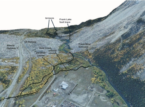
Source: Leckie (2021).
Acknowledgments
References
Alberta. 2025. “Frank Slide Interpretive Centre: Learn.” Frank Slide Interpretive Centre. Accessed Sept. 29, 2025. https://frankslide.ca/learn
Anderson, F.W. 1986. Turtle Mountain disaster: The saga of the Frank Slide. Saskatoon, SK: Frank W. Anderson.
Benko, B., and D. Stead. 1998. “The Frank Slide: a reexamination of the failure mechanism.” Can. Geotech. J., 35, 299-311.
Cruden, D.M., and J. Krahn. 1973. “A reexamination of the geology of the Frank Slide.” Can. Geotech. J., 10, 581-591.
Cruden, D.M., and J. Krahn. 1978. “Frank Rockslide, Alberta, Canada.” In Developments in geotechnical engineering, Vol. 14A: Rockslides and avalanches 1, B. Voight, ed. Amsterdam, the Netherlands: Elsevier, 97-112.
Cruden, D.M., and C.D. Martin. 2007. “Before the Frank Slide.” Can. Geotech. J., 44, 765-780.
Froese, C.R., F. Moreno, M. Jaboyedoff, and D.M. Cruden. 2009. “25 years of movement monitoring on South Peak, Turtle Mountain; Understanding the hazard.” Can. Geotech. J., 46, 256-269.
Froese, C.R., and F. Moreno. 2014. “Structure and components for the emergency response and warning system on Turtle Mountain, Alberta, Canada.” Nat. Hazard., 70, 1689-1712.
Government of Alberta (GOA). 2025. “Crowsnest Pass – Population.” Alberta: Regional Dashboard. Accessed Oct. 5, 2025. https://regionaldashboard.alberta.ca/region/crowsnest-pass/population/#/bymunicipality
Government of Canada (GOC). 2017. “ARCHIVED – Average Exchange Rates for 2003.” Government of Canada, Nov. 2. Accessed Oct. 5, 2025. https://www.canada.ca/en/revenue-agency/services/forms-publications/previous-year-forms-publications/archived-rc4152/archived-average-exchange-rates-2003.html
The Haunted Walk. 2025. “The day the mountain fell down.” The Haunted Walk. Accessed Oct. 5, 2025. https://hauntedwalk.com/news/the-day-the-mountain-fell-down/
Kostak, B., and D.M. Cruden. 1990. “The moire crack gauges on the crown of the Frank Slide.” Can. Geotech. J., 27, 835-840.
Langenberg, C.W., D. Pana, B.C. Richards, D.A. Spratt, and M.A. Lamb. 2007. Structural geology of the Turtle Mountain area near Frank, Alberta. Edmonton, AB: Alberta Energy and Utilities Board/Alberta Geological Survey (Report 2007-03).
Leckie, D. 2021. The scenic geology of Alberta: a roadside touring and hiking guide. Calgary, AB: Broken Poplars.
McConnell, R.G., and R.W. Brock. 1904. Report on the great landslide at Frank, Alta., 1903. Ottawa, ON: Department of the Interior, Dominion of Canada.
Mei, S., V. Poncos, and C. Froese. 2008. Mapping millimetre-scale ground deformation over the Frank Slide and South Peak of Turtle Mountain, Alberta, using spaceborne InSAR technology. Edmonton, AB: Energy Resources Conservation Board/Alberta Geol. Survey (Report 2007-09).
Moreno, F., M. Jaboyedoff, A. Pedrazzini, M. Charriere, and F. Humair. 2011. Frank Slide and Turtle Mountain early-warning system technical tour guidebook. Edmonton, AB: Energy Resources Conservation Board/Alberta Geological Survey (Report 139).
Pletcher, K. 2025. “Trans-Canada Highway.” Encyclopedia Britannica, Sept. 11. Accessed Sept. 29, 2025. https://www.britannica.com/topic/Trans-Canada-Highway
Read, R.S., W. Langenberg, D.M. Cruden, M. Field, R. Stewart, H. Bland, Z. Chen, C.R. Froese, D.S. Cavers, A.K. Bidwell, C. Murray, W.S. Anderson, A. Jones, J. Chen, D. McIntyre, D. Kenway, D.K. Bingham, I. Weir-Jones, J. Seraphim, J. Freeman, D. Spratt, M. Lamb, E. Herd, D. Martin, P. McLellan, and D. Pana. 2005. “Frank Slide a century later: The Turtle Mountain Monitoring Project.” In Landslide risk management, O. Hungr, R. Fell, R. Couture, and E. Eberhardt, eds. London, UK: CRC Press, 713-723.
Sharpe, C.F.S. 1938. Landslides and related phenomena: A study of mass-movements of soil and rock. New York, NY: Columbia University Press.
Terzaghi, K. 1950. “Mechanics of landslides.” In Application of geology to engineering practice: Berkey Volume, S. Paige, ed. New York, NY: Geological Society of America, 83-123.
Underground Miners. 2025. “Anthracite mine timbering methods.” Underground Miners. Accessed Oct. 5, 2025. https://undergroundminers.com/anthracite-mine-timbering-methods/
US Geological Survey (USGS). 2025. “Geology of Rocky Mountain National Park.” U.S. Geological Survey. Accessed Sept. 20, 2025. https://www.usgs.gov/geology-and-ecology-of-national-parks/geology-rocky-mountain-national-park
Van Gassen, W. and D.M. Cruden. 1989. “Momentum transfer and friction in the debris of rock avalanches.” Can. Geotech. J., 26, 623-628.
Webster, I. 2025. “CPI inflation calculator.” Inflation calculator. Accessed Oct. 5, 2025. https://www.in2013dollars.com/us/inflation